Volcanoes can erupt suddenly, but satellite technology now detects hidden ground shifts and heat changes. This helps scientists monitor remote volcanoes where ground sensors are scarce. These advanced tools provide vital information, improving preparedness for volcanic hazards worldwide. Early warnings allow for timely advisories and evacuations, saving lives and infrastructure.
Volcanic eruptions often appear sudden to nearby communities, even though the physical processes that drive them unfold over weeks, months, or years beneath the surface. Some volcanoes display clear warning signs such as earthquake swarms, rapid ground uplift, or increasing gas emissions. Others erupt with few obvious precursors detectable by traditional ground instruments. These so-called stealthy eruptions challenge scientists and emergency planners alike. In recent years, satellite technology has become one of the most important tools for detecting subtle volcanic unrest, especially in remote regions where ground monitoring is sparse.
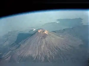
Image Credit: x/@grok
Why Some Volcanoes Seem Quiet Before They Erupt
Volcanoes do not erupt spontaneously without cause. Magma must migrate from deep reservoirs toward the surface. As it rises, it typically fractures rock, releases gases, and pushes the ground upward. These processes generate measurable signals such as seismic tremors and deformation. However, not all magma ascent behaves the same way. In some volcanic systems, magma can move through preexisting fractures that accommodate flow without producing large earthquakes. In other cases, surrounding rocks deform ductilely rather than breaking abruptly, reducing detectable seismic activity. If magma accumulates slowly or at depth, surface uplift may be small and difficult to measure with ground sensors.
A global analysis published in Nature Communications led by volcanologist Juliet Biggs examined satellite radar data from more than 500 volcanoes. The study found that deformation is strongly linked to eruptions, yet not all eruptions are preceded by easily detectable surface movement. Many volcanoes that did not show clear deformation did not erupt, but a significant fraction of eruptions occurred without strong precursory signals. Research on Mount Veniaminof in Alaska has shown that magma may accumulate in deep reservoirs where surrounding rock remains warm and flexible. In such settings, pressure can build with minimal seismic disturbance. When the eruption begins, it may seem sudden even though internal processes had been underway for months.
The Challenge of Limited Ground Monitoring
Although approximately 1,500 volcanoes worldwide are considered potentially active, only a small percentage are monitored by dense networks of seismometers, GPS stations, and gas sensors. Many volcanoes are located in remote regions, including island arcs, polar areas, or developing countries with limited monitoring infrastructure.
Ground instruments measure activity at specific points, but they cannot efficiently cover vast or inaccessible regions. This limitation means that subtle warning signs may go unnoticed until the eruption begins.
Live Events
How Satellites Detect Hidden Deformation
Satellites provide a global and repeatable view of Earth’s surface. One of the most powerful techniques for volcano monitoring is Interferometric Synthetic Aperture Radar (InSAR). This method compares radar images taken at different times to detect minute changes in ground elevation. Radar signals bounce off the surface and return to the satellite, allowing scientists to measure shifts in the ground as small as a few centimetres.
Because radar penetrates clouds and operates day or night, InSAR provides consistent coverage regardless of weather conditions. When magma accumulates beneath a volcano, even slight surface swelling creates characteristic interference patterns in radar images. These patterns allow researchers to map inflation and deflation cycles that signal magma movement. For example, satellite data captured ground uplift prior to the 2018 eruption of Sierra Negra in the Galápagos Islands. Time-series radar observations revealed sustained inflation of the caldera floor before the eruption and deflation afterwards, helping scientists understand the dynamics of the underlying magma reservoir.
Beyond Radar: Thermal and Gas Monitoring
Satellites also carry thermal sensors that detect changes in surface temperature. Rising magma or increased gas release can produce localised heat anomalies detectable from space. Multispectral instruments can identify sulfur dioxide plumes, which often increase before or during eruptions. The upcoming NASA-ISRO SAR Mission, known as NISAR, is designed to improve the frequency and precision of surface deformation measurements. More frequent radar coverage reduces the time gap between observations, increasing the chance of detecting rapid changes before eruption.
Machine learning systems are now being trained to automatically scan large volumes of satellite data. These algorithms flag unusual deformation patterns that may indicate volcanic unrest, helping scientists prioritise areas for closer inspection.
Limits of Prediction
Despite advances in satellite monitoring, precise prediction of eruption timing remains beyond current scientific capability. Some eruptions show deformation only days before activity begins. In other cases, deformation may occur without eruption.
Volcanic forecasting is therefore probabilistic rather than deterministic. Scientists assess whether unrest increases the likelihood of eruption within a given time window. Satellite data enhances this assessment by revealing subtle signals invisible to ground observers, especially at poorly instrumented volcanoes.
Why It Matters
Volcanic eruptions can disrupt air travel, damage infrastructure, and threaten lives through ash fall, lava flows, and pyroclastic surges. Early detection of unrest allows authorities to issue advisories, reroute aircraft, and prepare evacuations when necessary. Satellites do not eliminate uncertainty, but they extend humanity’s observational reach. By detecting centimetre-scale ground deformation, thermal anomalies, and gas emissions worldwide, they provide critical information that complements ground-based instruments.
Some volcanoes may appear quiet before they erupt, yet beneath that calm surface, magma continues to move. Satellite technologies allow scientists to observe these hidden processes with increasing precision, narrowing risk windows and improving preparedness in a world where volcanic hazards remain ever-present.

Subscription

 Global Desk

 as a Reliable and Trusted News Source
 Add Now!