

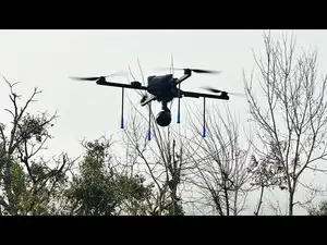
Under the order, VANA will support aerial photogrammetry and precision mapping, terrain and ground feature data collection, surveillance and aerial observation, and optical and thermal imaging, along with real time transmission of aerial video and mission data.
IZI, a Bhopal-based deep tech drone company, has secured an order from the Proof & Experimental Establishment (PXE), Defence Research and Development Organisation (DRDO), for the supply and deployment of its IZI VANA Surveillance Drones.
PXE is a specialised DRDO establishment involved in the testing and evaluation of defence systems and equipment. Under the order, VANA will support aerial photogrammetry and precision mapping, terrain and ground feature data collection, surveillance and aerial observation, and optical and thermal imaging, along with real time transmission of aerial video and mission data. The platform will also support precision navigation and waypoint based autonomous missions, flight and sensor data logging for post mission analysis, and operations in demanding environmental conditions, enabling the collection of detailed aerial and geospatial data for technical analysis and evaluation.
The VANA platform is configured with high resolution imaging, RGB and EO/IR sensing, GNSS navigation, onboard sensors and a dedicated Ground Control Station (GCS). Its mission architecture includes automated mission planning, geofencing, altitude and camera control, autonomous waypoint navigation and live data management through the GCS.
As part of the engagement, IZI will provide two DGCA-certified pilots for the first year, supporting flight operations and facilitating the transition of piloting capabilities to designated personnel during the warranty period. The contract identifies the platform as an Aerial Photogrammetry Platform (Drones), with the model specified as the IZI VANA Surveillance Drone and India as the country of origin.
Ishan Haydn, Founder, IZI, said in a statement, “Securing this order from DRDO’s Proof & Experimental Establishment is an important milestone for IZI and reflects our focus on developing indigenous unmanned systems for specialised government and defence applications. VANA has been designed around operational requirements where reliable aerial data, surveillance, precision navigation and mission level intelligence come together. This engagement will allow us to support PXE’s requirements while continuing to advance our capabilities in indigenous UAV technology.”
PXE is a specialised DRDO establishment involved in the testing and evaluation of defence systems and equipment. Under the order, VANA will support aerial photogrammetry and precision mapping, terrain and ground feature data collection, surveillance and aerial observation, and optical and thermal imaging, along with real time transmission of aerial video and mission data. The platform will also support precision navigation and waypoint based autonomous missions, flight and sensor data logging for post mission analysis, and operations in demanding environmental conditions, enabling the collection of detailed aerial and geospatial data for technical analysis and evaluation.
The VANA platform is configured with high resolution imaging, RGB and EO/IR sensing, GNSS navigation, onboard sensors and a dedicated Ground Control Station (GCS). Its mission architecture includes automated mission planning, geofencing, altitude and camera control, autonomous waypoint navigation and live data management through the GCS.
As part of the engagement, IZI will provide two DGCA-certified pilots for the first year, supporting flight operations and facilitating the transition of piloting capabilities to designated personnel during the warranty period. The contract identifies the platform as an Aerial Photogrammetry Platform (Drones), with the model specified as the IZI VANA Surveillance Drone and India as the country of origin.
Ishan Haydn, Founder, IZI, said in a statement, “Securing this order from DRDO’s Proof & Experimental Establishment is an important milestone for IZI and reflects our focus on developing indigenous unmanned systems for specialised government and defence applications. VANA has been designed around operational requirements where reliable aerial data, surveillance, precision navigation and mission level intelligence come together. This engagement will allow us to support PXE’s requirements while continuing to advance our capabilities in indigenous UAV technology.”
Add  as a Reliable and Trusted News Source
as a Reliable and Trusted News Source Add Now!












 ETPrime Membership